.
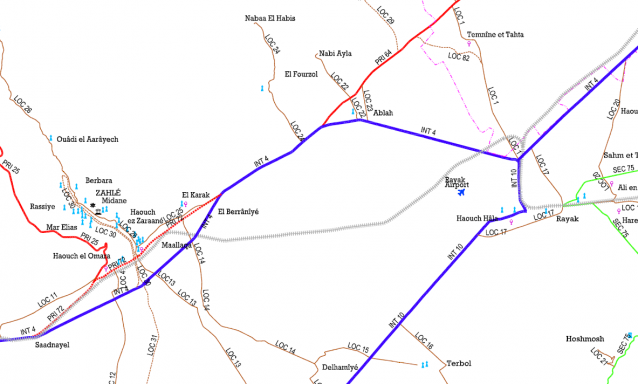
» Road Network Classification in Mohafazats of Bekaa and Baalbeck El Hermel Details
Category:
Transportation
Client:
Ministry of Public Works and Transport
Region:
Bekaa, Lebanon
Starting Date:
2007
Completion Date:
Ongoing
Details:
Using the most recent satellite photos to locate and identify the network of roads by superposing the photos to the geodesic maps produced by the Army to have the road network updated. Identifying then the different segments of road and have them classified. The study includes land surveying of the road segments classified.
» OTHER PROJECTS
Conveying of Antelias Grotto Water Sources to Dbayeh Treatment Plant
The project consists of building an underground diversion dam and intake structure inside … »
Rehabilitation of the Bared Main Irrigation Channel – Akkar
The Bared main irrigation channel in Akkar runs over 13 km from the … »
Sewage Networks in El Mari and EL Fardis & Surface Drainage Channels in Kfarhamam
Population survey and data collection for existing wastewater facilities in Caza Hasbaya. Identifying … »
Agricultural Roads in Akkar, Danieh and Hermel
The project consists of the design and construction supervision of agricultural roads in … »
Upgrade of Roundabout at Dekwaneh Square
Design of a 60m diameter roundabout connecting seven arms of the intersection in … »