.
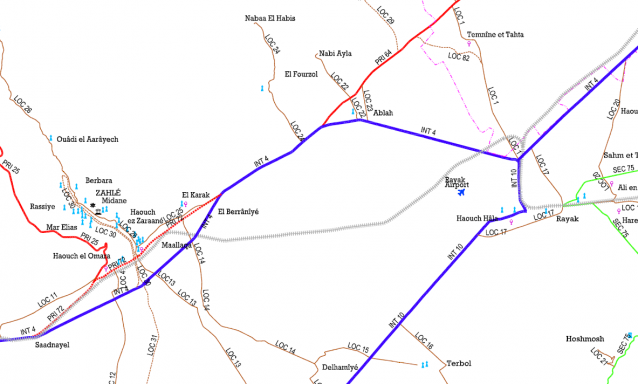
» Road Network Classification in Mohafazats of Bekaa and Baalbeck El Hermel Details
Category:
Transportation
Client:
Ministry of Public Works and Transport
Region:
Bekaa, Lebanon
Starting Date:
2007
Completion Date:
Ongoing
Details:
Using the most recent satellite photos to locate and identify the network of roads by superposing the photos to the geodesic maps produced by the Army to have the road network updated. Identifying then the different segments of road and have them classified. The study includes land surveying of the road segments classified.
» OTHER PROJECTS
Lebanon Water and Wastewater Sector Support Program (LWPP)
In 2010, USAID commissioned Development Alternatives Inc. (DAI) with the implementation of the … »
National Roads Program Second Year Lot 1 Rehabilitation Design Within the framework of … »
The assignment called for the supervision of different infrastructure rehabilitation works in the … »
Consulting Services for the Supervision of Water Projects in Lebanon
In 2010, the International Management Group (IMG) commissioned Kredo with the Supervision of … »
Roads in Al-Arkoub, Yohmor and Taybeh
The project consists of the design and construction supervision for service and agricultural … »