.
» Nabi Sbat – Toufail Road Details
Category:
Transportation
Client:
Ministry of Public Works and Transport
Region:
Lebanon
Starting Date:
2001
Completion Date:
2002
Details:
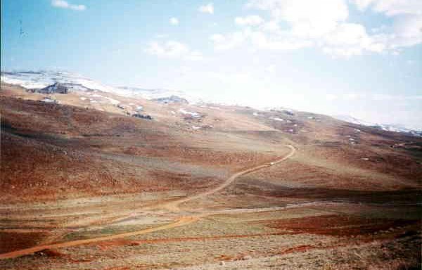
Toufail is an isolated Lebanese Village situated near the Syrian Border and can only be accessed, at present, by crossing into Syria and driving through Damascus and Saïdnaya.
The Minister of Public Works and Transport commissioned KREDO with the planning and design of a 24-km road that connects the town of Baalbeck with the village of Toufail. And that starts at Nabi Sbat Shrine and ends at the Syrian Border.
The projected road crosses the heights of the Anti Lebanon chain of mountains at an average altitude of 1800 meters. The tasks involved included a major topographical survey of a wide corridor where the road axis was set in addition to a geotechnical and a hydrological survey. The carriageway was designed to be 9m wide composed of 6m bituminous pavement and two 1.5m shoulders. Due to the remote location of the road and the prevailing environmental conditions the construction of retaining walls was completely avoided, and replaced by mild side slopes.
» OTHER PROJECTS
Optimization and updating of rehabilitation studies in cazas of Batroun, Jbeil and Akkar
Upon the request of the World Bank and within the framework of a … »
Construction of Reservoirs on the Hills of South Beirut
Beirut-Awali water pipeline project Component 2 In 2010, the Office des Eaux to … »
300km of Sewers Within Nabatiyeh & South Lebanon Mohafazats
The master plan required covered the southern part of the country namely both … »
Evaluation of Fixed Assets in BMLWE
In 2010, the Etablissement des Eaux de Beyrouth et du Mont Liban (EBML/BMLWE) … »
Road Network Classification in Mohafazats of Bekaa and Baalbeck El Hermel
Using the most recent satellite photos to locate and identify the network of … »